
 X
X
 facebook
 WhatsApp
 Email
Email
Introduction
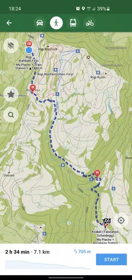
Organic Maps: Hike Bike Drive is a privacy-first offline mapping app designed for hiking, cycling and driving, offering downloadable maps, turn-by-turn voice navigation and detailed trail information so you can explore without cellular data or tracking. The app appeals to users who want a fast, battery-friendly navigation tool with a simple interface and no ads or mandatory sign-ups. Community contributors continuously improve map detail, while a small team maintains the project and welcomes user reports to correct missing places and navigation issues in future map updates.
Key Features
⭐ Organic Maps: Hike Bike Drive is free and open-source, running without ads, trackers or unnecessary permissions.
⭐ Detailed offline maps with community-contributed places and trails that often fill gaps left by mainstream map services.
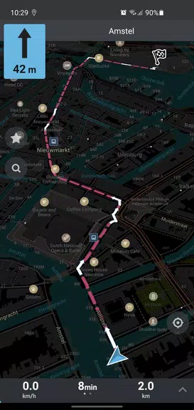
⭐ Turn-by-turn navigation for walking, cycling and driving with clear voice guidance and offline routing.
⭐ Topographic support including contour lines, elevation profiles, peaks and slope information for outdoor planning.
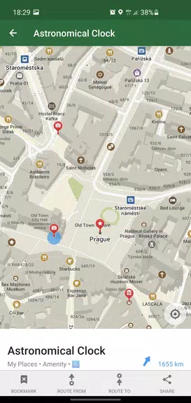
⭐ Fast offline search plus bookmark and track import/export in KML, KMZ and GPX formats.
⭐ Dark mode and a lightweight, battery-friendly interface optimized for long trips.
Advantages
✅ Organic Maps: Hike Bike Drive prioritizes user privacy with no ads, no trackers and no mandatory registration.
✅ Smooth, responsive offline experience that saves battery and prevents unexpected mobile data usage.
✅ Focused, easy-to-use interface that keeps the most useful tools for navigation and outdoor use.
✅ Community-driven updates and an attentive team mean maps improve over time and reported issues are addressed.
Disadvantages
❎ No public transport routing or satellite imagery yet, so city transit planning and aerial views are not available.
❎ Reliance on community edits means map detail varies by region and some areas may be incomplete.
❎ A small volunteer team can result in a slower development pace compared with large commercial map providers.
Development Team
Organic Maps: Hike Bike Drive is built and maintained by a small, community-driven team and volunteer contributors who work on the project in their spare time; they encourage users to edit the shared mapping database and to report missing features or errors so fixes can be included in future updates.
Information
 Google Play
User Comments

RidePueblo puts real-time transit information in your pocket so residents and visitors can navigate public transportation across the City of Pueblo with confidence. The app displays live arrival times and moving vehicle locations on an interactive map, shows route maps and timetables, and locates nearby stops based on your current GPS position. Whether you commute, attend classes, or are visiting for an event, RidePueblo helps reduce uncertainty by delivering current transit details in a compact, phone-friendly interface.

77 Transporte - Motorista is a dedicated driver app built to help professional drivers receive, evaluate and manage ride requests with speed and clarity. 77 Transporte - Motorista places emphasis on essential tools — timely trip alerts, a visible distance preview to help you decide whether to accept, and a direct call option that uses your device carrier for voice communication — so drivers can remain productive during active hours without unnecessary features getting in the way.

IZI Recarga EV is a practical mobile app designed to help electric vehicle drivers locate charging points, start and monitor charging sessions, and track consumption so everyday charging is simpler and more sustainable. The app puts a searchable map and session controls in your hands, offers clear billing and usage history to help plan trips and manage running costs, and connects drivers to a network of stations that prioritize renewable energy and predictable service.

Surf Life Log is a compact surfing logbook app that helps surfers record sessions, track conditions and choose better spots. The app lets you save date and time, location, wave size, wind direction and force, crowd level, photos, notes and personal ratings so you can review past rides and identify what works. Built for individual device use, Surf Life Log visualizes your activity with simple statistics and charts and includes a map-based surf-spot search. Surfers who want organized logs and clear insights into their preferred conditions will find this tool practical and straightforward.

ES Car - Motorista is a driver-focused mobile app built to connect professional drivers with nearby ride requests, enabling them to accept trips, manage pickups and improve daily earnings with clear, practical tools. The interface prioritizes real-time notifications so drivers see incoming offers immediately, and ES Car - Motorista gives a quick distance preview before a driver commits to a booking. With pre-registered users and an option to call passengers directly through the app for urgent coordination, the design emphasizes predictable interactions and safer exchanges between drivers and riders.

AUVES is a private transportation app designed to make requesting rides quick and predictable from your Android device; AUVES appears in this description to help you identify the service and understand how it fits into daily travel. From the initial booking screen you can set a pickup location, enter or select a destination, and review an estimated fare before confirming a trip. The app is built around straightforward controls and clear trip information so that both occasional users and regular commuters can complete bookings in seconds and monitor the ride in real time.