
 X
X
 facebook
 WhatsApp
 Email
Email
Introduction
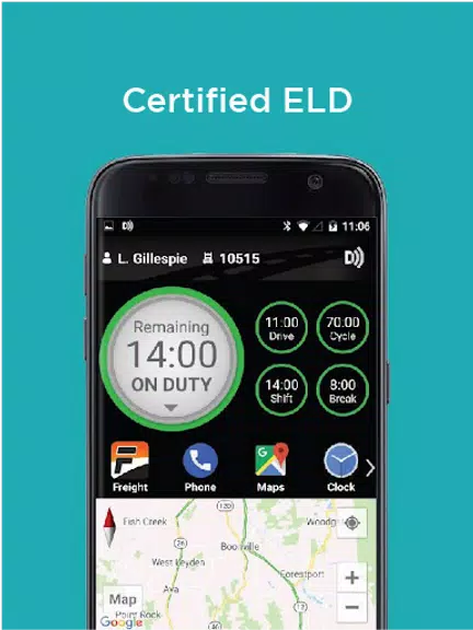
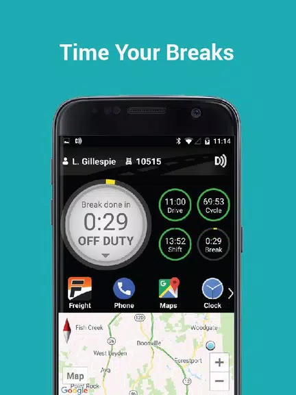
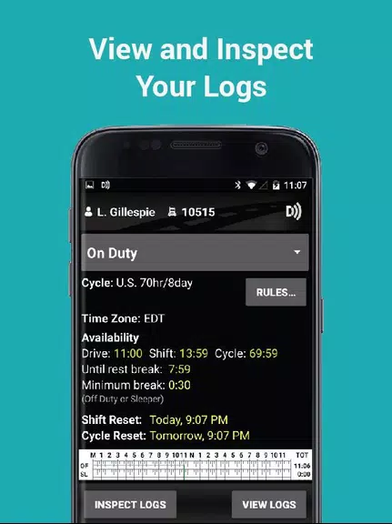
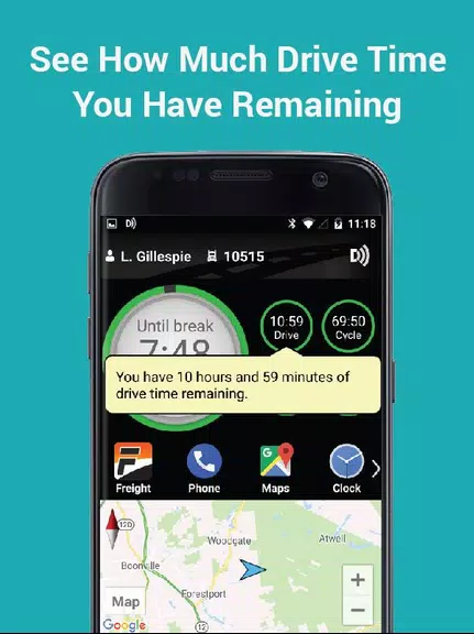
Stay compliant and efficient on the road with FC BigRoad ELD. This user-friendly electronic logging device makes tracking your Hours of Service a breeze, ensuring you stay within regulations and avoid fines. Say goodbye to paperwork and guesswork as the app calculates your remaining drive time and sends logs and documents directly to your fleet manager. With quick and easy DVIR creation, in-app chat to stay connected, and support for US and Canadian regulations, FC BigRoad ELD has everything you need to keep your business running smoothly.
Features of FC BigRoad ELD:
⭐ Easy-to-use electronic logging device certified with FMCSA and 3rd Party Certified in Canada
⭐ Easily track hours-of-service and create ELD compliant logs by connecting to DashLink ELD devices
⭐ Proactive notifications of errors and violations to help avoid fines and out-of-service time
⭐ Say goodbye to paperwork and faxes by sending logs, vehicle inspection reports, and fuel purchase receipts directly through the app
⭐ Clean, compliant ELD logs displayed for inspectors to review, with easy methods to send logs to safety officials
⭐ Stay connected with fleet managers and other drivers through in-app chat, and easily capture and store documents and photos
Conclusion:
The FC BigRoad ELD App is a user-friendly and efficient tool for tracking hours-of-service and creating compliant ELD logs. With features such as error notifications, easy document sending, and in-app chat, it helps drivers and fleet managers stay organized and connected. Click to download and simplify your fleet management today!
Information
 Google Play
User Comments

RidePueblo puts real-time transit information in your pocket so residents and visitors can navigate public transportation across the City of Pueblo with confidence. The app displays live arrival times and moving vehicle locations on an interactive map, shows route maps and timetables, and locates nearby stops based on your current GPS position. Whether you commute, attend classes, or are visiting for an event, RidePueblo helps reduce uncertainty by delivering current transit details in a compact, phone-friendly interface.

77 Transporte - Motorista is a dedicated driver app built to help professional drivers receive, evaluate and manage ride requests with speed and clarity. 77 Transporte - Motorista places emphasis on essential tools — timely trip alerts, a visible distance preview to help you decide whether to accept, and a direct call option that uses your device carrier for voice communication — so drivers can remain productive during active hours without unnecessary features getting in the way.

IZI Recarga EV is a practical mobile app designed to help electric vehicle drivers locate charging points, start and monitor charging sessions, and track consumption so everyday charging is simpler and more sustainable. The app puts a searchable map and session controls in your hands, offers clear billing and usage history to help plan trips and manage running costs, and connects drivers to a network of stations that prioritize renewable energy and predictable service.

Surf Life Log is a compact surfing logbook app that helps surfers record sessions, track conditions and choose better spots. The app lets you save date and time, location, wave size, wind direction and force, crowd level, photos, notes and personal ratings so you can review past rides and identify what works. Built for individual device use, Surf Life Log visualizes your activity with simple statistics and charts and includes a map-based surf-spot search. Surfers who want organized logs and clear insights into their preferred conditions will find this tool practical and straightforward.

ES Car - Motorista is a driver-focused mobile app built to connect professional drivers with nearby ride requests, enabling them to accept trips, manage pickups and improve daily earnings with clear, practical tools. The interface prioritizes real-time notifications so drivers see incoming offers immediately, and ES Car - Motorista gives a quick distance preview before a driver commits to a booking. With pre-registered users and an option to call passengers directly through the app for urgent coordination, the design emphasizes predictable interactions and safer exchanges between drivers and riders.

AUVES is a private transportation app designed to make requesting rides quick and predictable from your Android device; AUVES appears in this description to help you identify the service and understand how it fits into daily travel. From the initial booking screen you can set a pickup location, enter or select a destination, and review an estimated fare before confirming a trip. The app is built around straightforward controls and clear trip information so that both occasional users and regular commuters can complete bookings in seconds and monitor the ride in real time.