
 X
X
 facebook
 WhatsApp
 Email
Email

Introduction
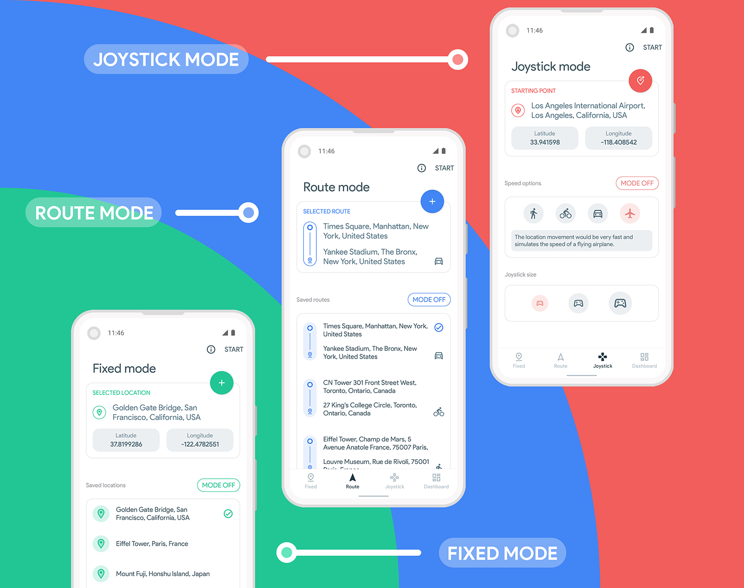
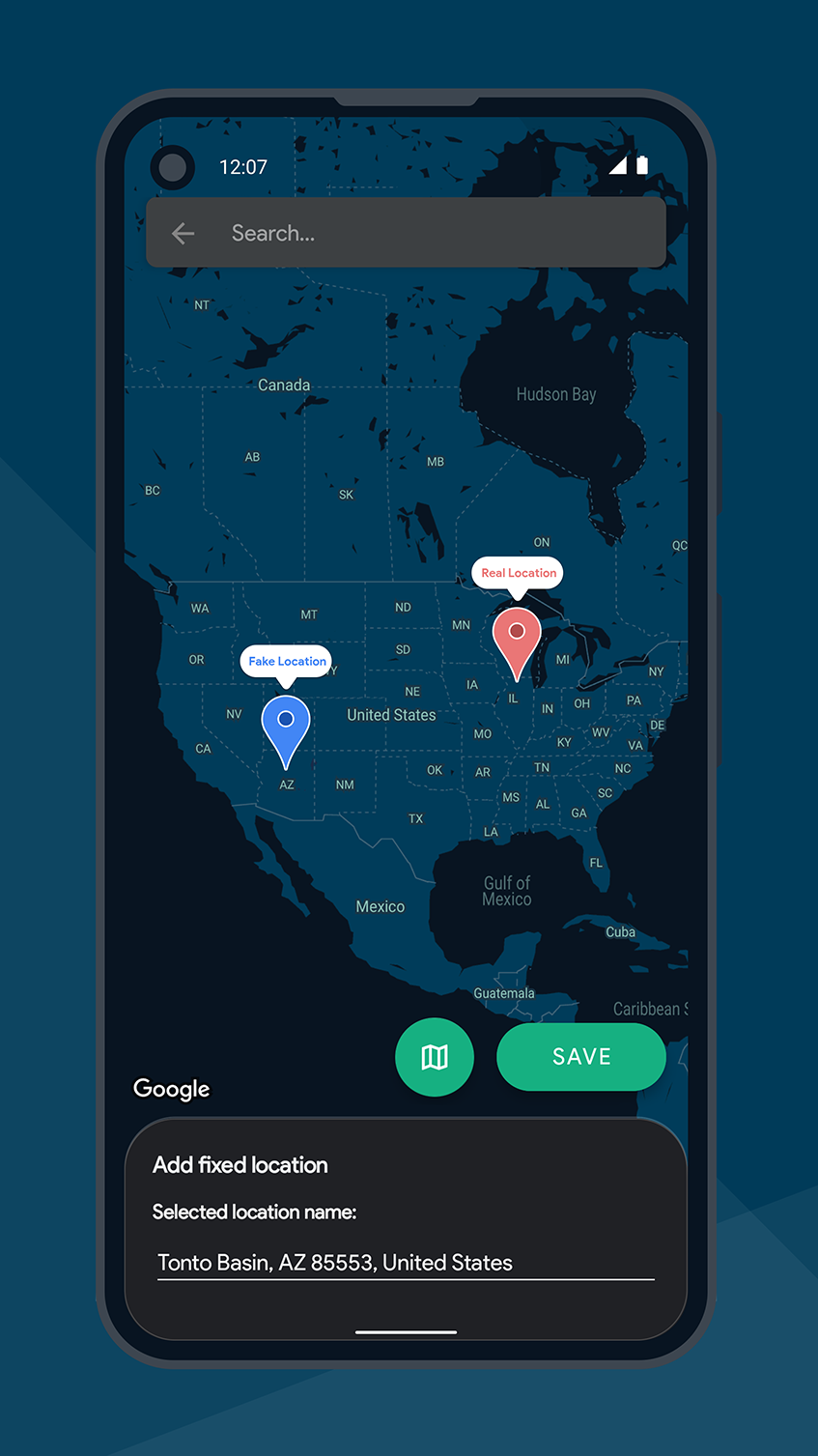
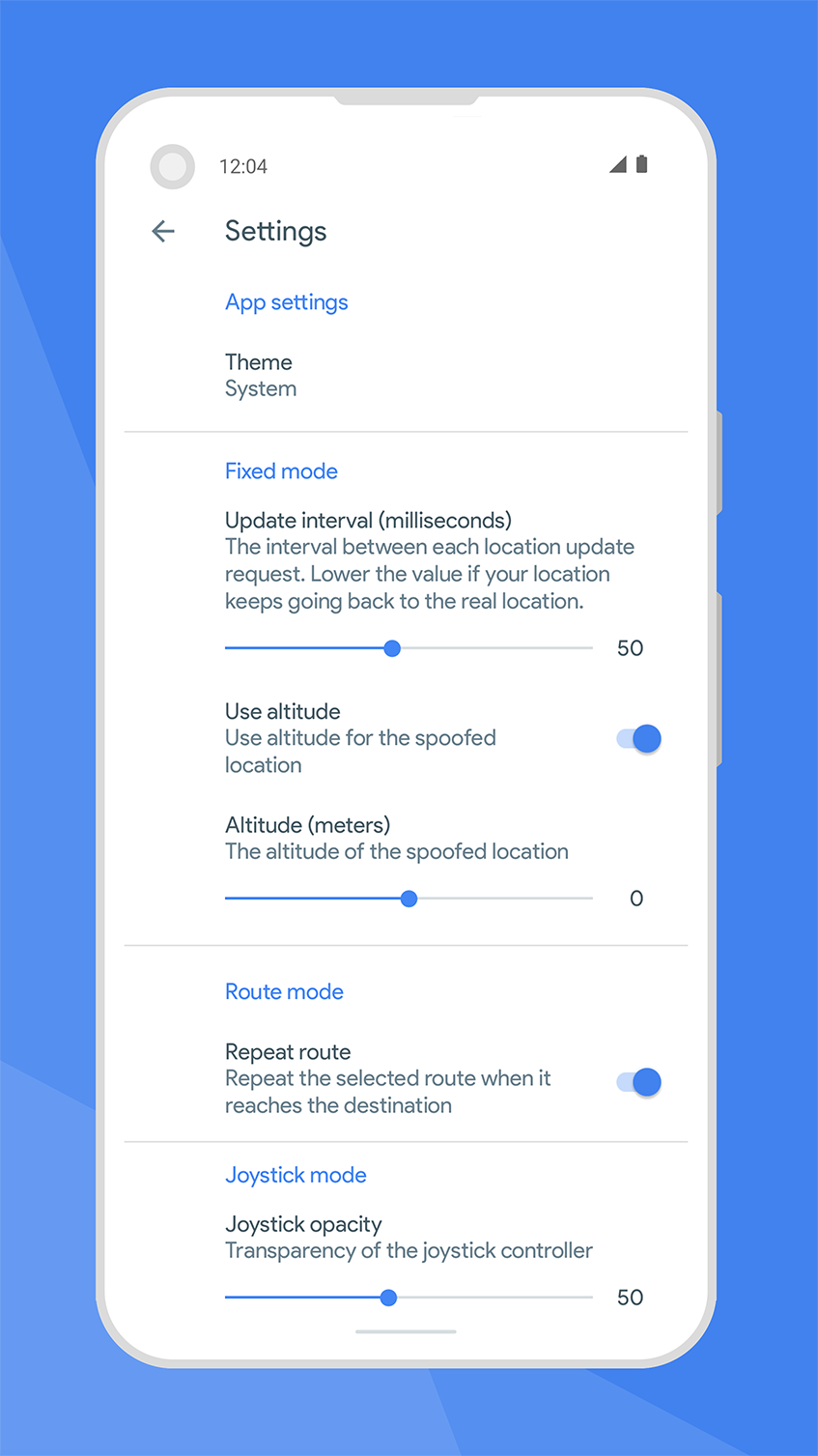
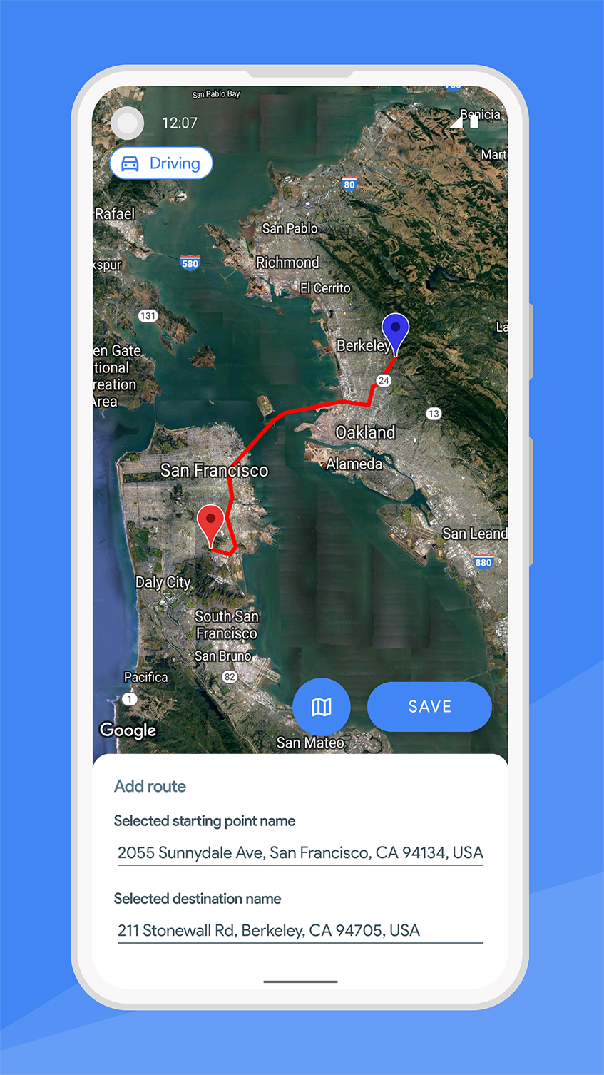
Fake GPS Joystick and Route is the ultimate invisible teleportation tool that allows you to seamlessly change your device's location with just a few clicks. With three different modes to choose from, including Fixed Mode, Route Mode, and Joystick Mode, this app offers endless possibilities for location spoofing. Whether you want to trick your friends on social media, test GPS functionality in apps, or explore new virtual worlds in location-based games, Fake GPS Joystick and Route has got you covered. Just be sure to use it responsibly, as its power comes with great responsibility. With its ease of use and unmatched control over your device's location, Fake GPS Joystick and Route is a game-changer for anyone looking to challenge the boundaries of GPS technology.
Features of Fake GPS Joystick and Route:
- Seamless Integration: The app seamlessly integrates with your operating system, creating convincing location illusions.
- Multiple Modes: Offers three different modes - Fixed, Route, and Joystick - for a variety of location spoofing options.
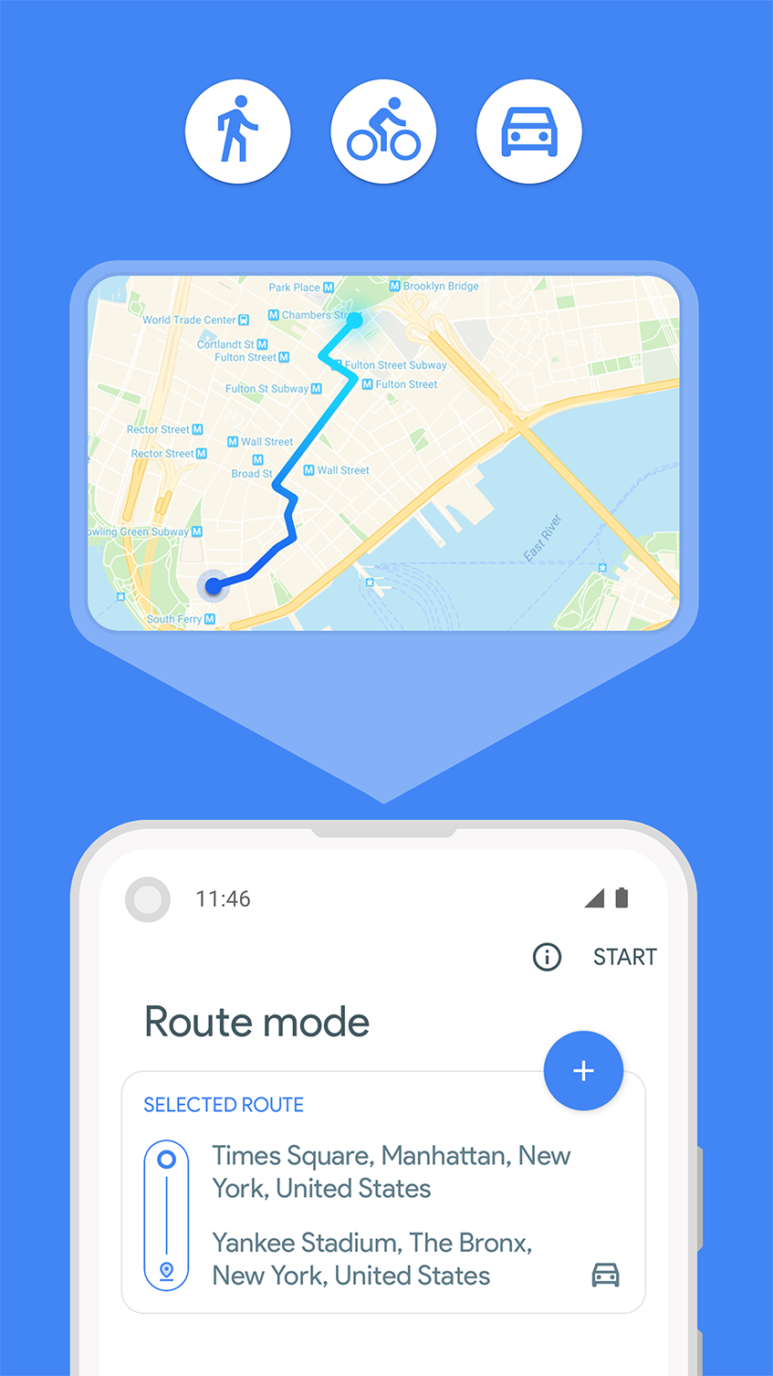
- Sophisticated Features: Joystick Mode allows users to navigate freely in any direction, making it ideal for location-based gaming.
- Realistic Simulation: Route Mode provides accurate speed variations and turn-by-turn pathing for a believable experience.
- Responsible Use: Emphasizes the importance of using the app responsibly for testing purposes to avoid misuse.
FAQs:
Q: How convincing is the spoofing for apps like dating/social media?
A: Extremely effective initially. Apps showed my "Paris" location instantly. However, discrepancies may raise flags over time.
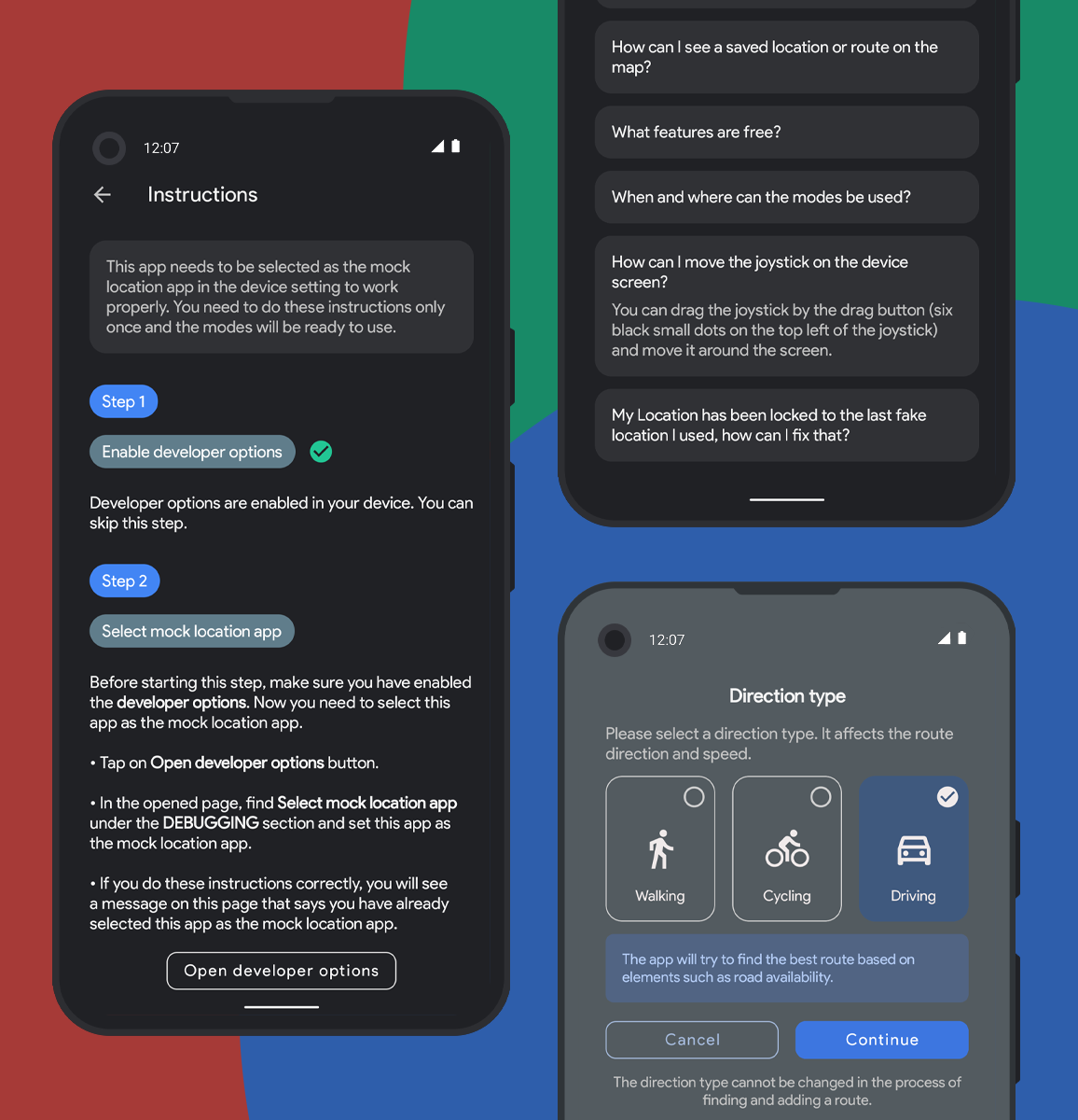
Q: Is the initial setup process complicated?
A: Setting up Developer Options may feel slightly technical, but the app's unique functionalities make it worth the effort.
Q: Can the app be used for gaming purposes?
A: Yes, Joystick Mode is specifically designed for gaming and provides a realistic and engaging experience.
Conclusion:
Transform your device into an invisible teleportation tool with Fake GPS Joystick and Route. Seamlessly integrated with your system, this app offers sophisticated features like Joystick Mode for immersive gaming experiences and Route Mode for accurate location simulations. While the setup process may require some technical know-how, the payoff is unparalleled control over your device's location. Use this powerful tool responsibly for testing purposes to explore new possibilities and reshape your interaction with GPS-dependent services.
Information
 Google Play

Social networking apps have become essential tools in everyday life, making communication with others more convenient. These apps allow you to easily stay in touch with old friends while also providing opportunities to meet new people, helping to expand your social network beyond its usual boundaries. This page features a handpicked selection of the best social apps, making it your go-to choice for mobile socializing!


User Comments

RidePueblo puts real-time transit information in your pocket so residents and visitors can navigate public transportation across the City of Pueblo with confidence. The app displays live arrival times and moving vehicle locations on an interactive map, shows route maps and timetables, and locates nearby stops based on your current GPS position. Whether you commute, attend classes, or are visiting for an event, RidePueblo helps reduce uncertainty by delivering current transit details in a compact, phone-friendly interface.

77 Transporte - Motorista is a dedicated driver app built to help professional drivers receive, evaluate and manage ride requests with speed and clarity. 77 Transporte - Motorista places emphasis on essential tools — timely trip alerts, a visible distance preview to help you decide whether to accept, and a direct call option that uses your device carrier for voice communication — so drivers can remain productive during active hours without unnecessary features getting in the way.

IZI Recarga EV is a practical mobile app designed to help electric vehicle drivers locate charging points, start and monitor charging sessions, and track consumption so everyday charging is simpler and more sustainable. The app puts a searchable map and session controls in your hands, offers clear billing and usage history to help plan trips and manage running costs, and connects drivers to a network of stations that prioritize renewable energy and predictable service.

Surf Life Log is a compact surfing logbook app that helps surfers record sessions, track conditions and choose better spots. The app lets you save date and time, location, wave size, wind direction and force, crowd level, photos, notes and personal ratings so you can review past rides and identify what works. Built for individual device use, Surf Life Log visualizes your activity with simple statistics and charts and includes a map-based surf-spot search. Surfers who want organized logs and clear insights into their preferred conditions will find this tool practical and straightforward.

ES Car - Motorista is a driver-focused mobile app built to connect professional drivers with nearby ride requests, enabling them to accept trips, manage pickups and improve daily earnings with clear, practical tools. The interface prioritizes real-time notifications so drivers see incoming offers immediately, and ES Car - Motorista gives a quick distance preview before a driver commits to a booking. With pre-registered users and an option to call passengers directly through the app for urgent coordination, the design emphasizes predictable interactions and safer exchanges between drivers and riders.

AUVES is a private transportation app designed to make requesting rides quick and predictable from your Android device; AUVES appears in this description to help you identify the service and understand how it fits into daily travel. From the initial booking screen you can set a pickup location, enter or select a destination, and review an estimated fare before confirming a trip. The app is built around straightforward controls and clear trip information so that both occasional users and regular commuters can complete bookings in seconds and monitor the ride in real time.