 X
X
 facebook
 WhatsApp
 Email
Email
Introduction
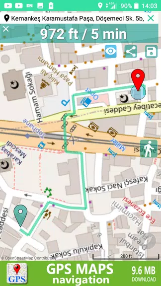
Looking for a user-friendly GPS and navigation app that won't collect your data? Look no further than GPS Maps & Navigations! This app is the answer to all your location and direction needs. With a simple interface and helpful features like instant live address search, one-touch navigation, and the ability to save and share locations, this app is a must-have for anyone on the go. Say goodbye to overly complicated GPS apps and hello to easy, efficient navigation. Try it out today and experience the fastest way to navigate with GPS Maps & Navigations.
Features of GPS Maps & Navigations:
> Instant Live Address and Zipcode Worldwide
Experience the convenience of quickly finding live addresses and zip codes no matter where you are in the world. GPS Maps & Navigations makes it easy for you to access this information with just a few taps on your device.
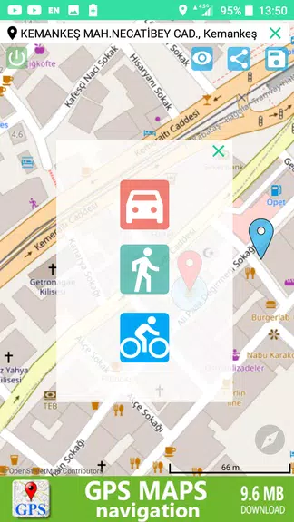
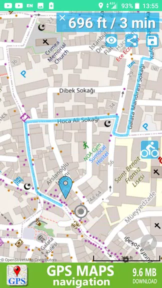
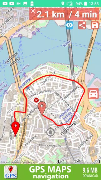
> Easy One-touch Navigation Feature
Navigate to your desired destination effortlessly with the easy one-touch navigation feature of it. You can simply input your destination and let the app guide you on the fastest route.
> Save & Share Locations
With the ability to save and share locations, it allows you to easily keep track of your favorite spots and share them with friends and family. This feature is perfect for planning meetups or sharing travel recommendations.
> Compass Embedded in the Map
Navigate with precision using the compass embedded in the map of it. This handy tool ensures that you always know your orientation and can easily find your way to your destination.
Tips for Users:
> Take Advantage of the Speak & Search Feature
Utilize the speak & search feature on the map to quickly find locations using voice commands. This can save you time and effort when inputting addresses or landmarks.
> Organize Your Favorite Destinations
Make use of the categorized address list to organize your favorite destinations for easy access. Whether it's your go-to restaurants or must-visit attractions, you can quickly navigate to these spots with just a few taps.
> Share Your Location with a Screenshot or Photo
Enhance your location sharing by adding a screenshot or photo to the shared location. This personal touch can provide additional context to your shared spots and make it easier for others to identify them.
Conclusion:
GPS Maps & Navigations offers a seamless and user-friendly experience for navigating and sharing locations. With its instant live address feature, easy one-touch navigation, and compass embedded in the map, this app simplifies the way you use GPS maps. Take advantage of the various features and playing tips to make the most out of your navigation experience. Download GPS Maps & Navigations now and enjoy the convenience of fast and accurate location mapping.
Information
 Google Play
Old Versions
Other Games by the Same SoftCodes

User Comments

RidePueblo puts real-time transit information in your pocket so residents and visitors can navigate public transportation across the City of Pueblo with confidence. The app displays live arrival times and moving vehicle locations on an interactive map, shows route maps and timetables, and locates nearby stops based on your current GPS position. Whether you commute, attend classes, or are visiting for an event, RidePueblo helps reduce uncertainty by delivering current transit details in a compact, phone-friendly interface.

77 Transporte - Motorista is a dedicated driver app built to help professional drivers receive, evaluate and manage ride requests with speed and clarity. 77 Transporte - Motorista places emphasis on essential tools — timely trip alerts, a visible distance preview to help you decide whether to accept, and a direct call option that uses your device carrier for voice communication — so drivers can remain productive during active hours without unnecessary features getting in the way.

IZI Recarga EV is a practical mobile app designed to help electric vehicle drivers locate charging points, start and monitor charging sessions, and track consumption so everyday charging is simpler and more sustainable. The app puts a searchable map and session controls in your hands, offers clear billing and usage history to help plan trips and manage running costs, and connects drivers to a network of stations that prioritize renewable energy and predictable service.

Surf Life Log is a compact surfing logbook app that helps surfers record sessions, track conditions and choose better spots. The app lets you save date and time, location, wave size, wind direction and force, crowd level, photos, notes and personal ratings so you can review past rides and identify what works. Built for individual device use, Surf Life Log visualizes your activity with simple statistics and charts and includes a map-based surf-spot search. Surfers who want organized logs and clear insights into their preferred conditions will find this tool practical and straightforward.

ES Car - Motorista is a driver-focused mobile app built to connect professional drivers with nearby ride requests, enabling them to accept trips, manage pickups and improve daily earnings with clear, practical tools. The interface prioritizes real-time notifications so drivers see incoming offers immediately, and ES Car - Motorista gives a quick distance preview before a driver commits to a booking. With pre-registered users and an option to call passengers directly through the app for urgent coordination, the design emphasizes predictable interactions and safer exchanges between drivers and riders.

AUVES is a private transportation app designed to make requesting rides quick and predictable from your Android device; AUVES appears in this description to help you identify the service and understand how it fits into daily travel. From the initial booking screen you can set a pickup location, enter or select a destination, and review an estimated fare before confirming a trip. The app is built around straightforward controls and clear trip information so that both occasional users and regular commuters can complete bookings in seconds and monitor the ride in real time.