 X
X
 facebook
 WhatsApp
 Email
Email
Introduction
Explore the great outdoors like never before with Norgeskart Outdoors designed for outdoor enthusiasts. No matter what your favorite activity is - from hunting and fishing to hiking, cycling, skiing, or boating - this app has your back. With the ability to register, measure, and categorize points of interest, routes, and tracks, you can easily plan and organize your adventures. Choose from over 40 maps and map layers, including beautiful maps of Norway, and even create your own custom map layers. Experience the ultimate outdoor adventure with this app today!
Features of Norgeskart Outdoors:
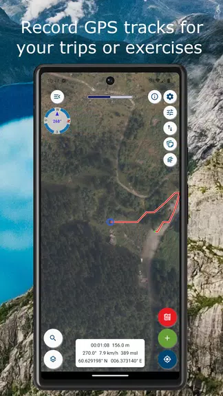
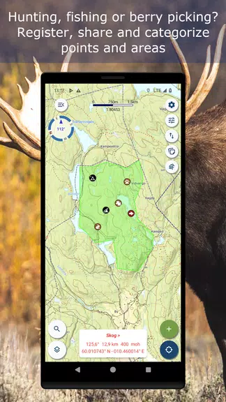
⭐ Register, measure and categorise
- Record points of interest, routes, and areas
- Organise data with custom categories and icons
- Share files easily with others
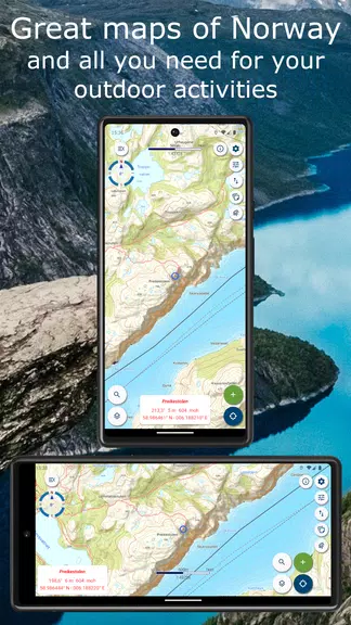
⭐ Great outdoor maps and map layers
- Choose from over 40 maps and layers
- Download beautiful maps of Norway for offline use
- Combine multiple layers for a comprehensive overview
⭐ Own map and map layers
- Add your own maps and layers from various services
- Explore additional maps from geonorge.no
- Support for Mercator and UTM33 projections
Tips for Users:
⭐ Plan your trip with TellTur
- Get trip suggestions and descriptions from telltur.no
- Compete with others to visit the most places
⭐ Utilize the Pro subscription
- Access advanced features like creating and measuring areas
- Download Norwegian maps for offline use
- Synchronize data across devices and the map portal
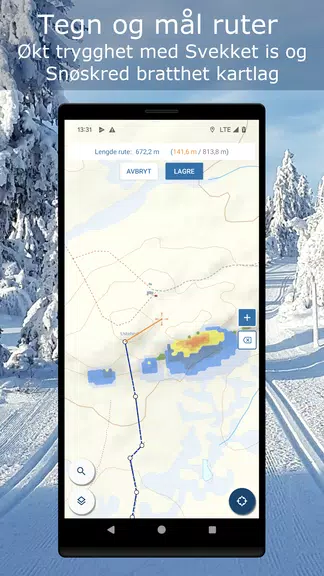
⭐ Discover different map layers
- Explore topo maps, historical maps, and trails
- Check out avalanche awareness and snow conditions for skiing
Conclusion:
Norgeskart Outdoors is a comprehensive outdoor app that caters to all your adventure needs. With a wide range of features, maps, and layers, this app ensures that you have the tools to navigate and explore the great outdoors effectively. Upgrade to the Pro subscription for additional benefits and support the continued development of this exciting app. Download Norgeskart Outdoors today and elevate your outdoor experiences!
Information
 Google Play
User Comments

RidePueblo puts real-time transit information in your pocket so residents and visitors can navigate public transportation across the City of Pueblo with confidence. The app displays live arrival times and moving vehicle locations on an interactive map, shows route maps and timetables, and locates nearby stops based on your current GPS position. Whether you commute, attend classes, or are visiting for an event, RidePueblo helps reduce uncertainty by delivering current transit details in a compact, phone-friendly interface.

77 Transporte - Motorista is a dedicated driver app built to help professional drivers receive, evaluate and manage ride requests with speed and clarity. 77 Transporte - Motorista places emphasis on essential tools — timely trip alerts, a visible distance preview to help you decide whether to accept, and a direct call option that uses your device carrier for voice communication — so drivers can remain productive during active hours without unnecessary features getting in the way.

IZI Recarga EV is a practical mobile app designed to help electric vehicle drivers locate charging points, start and monitor charging sessions, and track consumption so everyday charging is simpler and more sustainable. The app puts a searchable map and session controls in your hands, offers clear billing and usage history to help plan trips and manage running costs, and connects drivers to a network of stations that prioritize renewable energy and predictable service.

Surf Life Log is a compact surfing logbook app that helps surfers record sessions, track conditions and choose better spots. The app lets you save date and time, location, wave size, wind direction and force, crowd level, photos, notes and personal ratings so you can review past rides and identify what works. Built for individual device use, Surf Life Log visualizes your activity with simple statistics and charts and includes a map-based surf-spot search. Surfers who want organized logs and clear insights into their preferred conditions will find this tool practical and straightforward.

ES Car - Motorista is a driver-focused mobile app built to connect professional drivers with nearby ride requests, enabling them to accept trips, manage pickups and improve daily earnings with clear, practical tools. The interface prioritizes real-time notifications so drivers see incoming offers immediately, and ES Car - Motorista gives a quick distance preview before a driver commits to a booking. With pre-registered users and an option to call passengers directly through the app for urgent coordination, the design emphasizes predictable interactions and safer exchanges between drivers and riders.

AUVES is a private transportation app designed to make requesting rides quick and predictable from your Android device; AUVES appears in this description to help you identify the service and understand how it fits into daily travel. From the initial booking screen you can set a pickup location, enter or select a destination, and review an estimated fare before confirming a trip. The app is built around straightforward controls and clear trip information so that both occasional users and regular commuters can complete bookings in seconds and monitor the ride in real time.