
 X
X
 facebook
 WhatsApp
 Email
Email
Introduction
Transform your hunting experience with the ultimate tool for navigating the great outdoors - HuntStand: GPS Maps & Tools! With over 6 million downloads and recognized as the Best App for Hunters by Outdoor Life Magazine, HuntStand is a must-have for any hunting enthusiast. Access property lines, track deer movement, view hunting forecasts, and share hunt areas with friends and family all in one convenient app. Experience the power of GPS mapping, HuntZone wind forecasting, and high-resolution satellite imagery to enhance your scouting and hunting trips.
Features of HuntStand: GPS Maps & Tools:
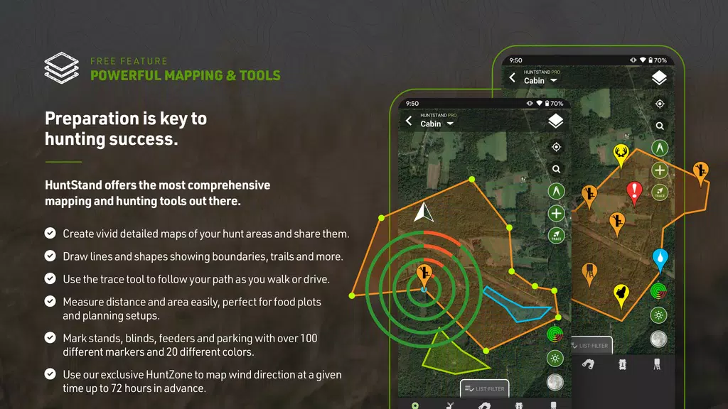
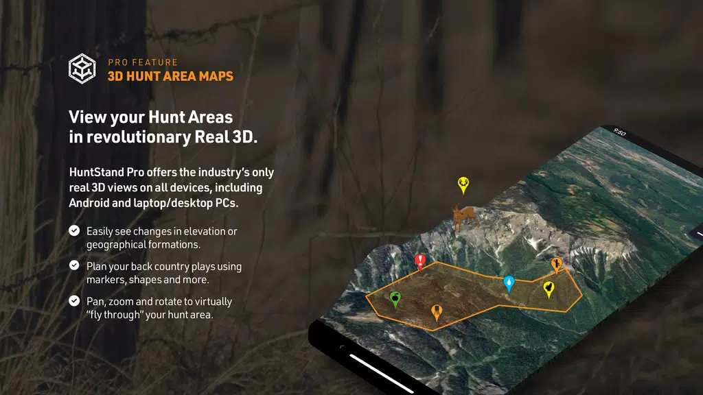
> Comprehensive Mapping Tools: HuntStand offers a wide range of mapping tools, including GPS mapping, HuntZone wind forecasting, digital rangefinder, and high-resolution satellite imagery. These tools help hunters plan and navigate with precision in the field.
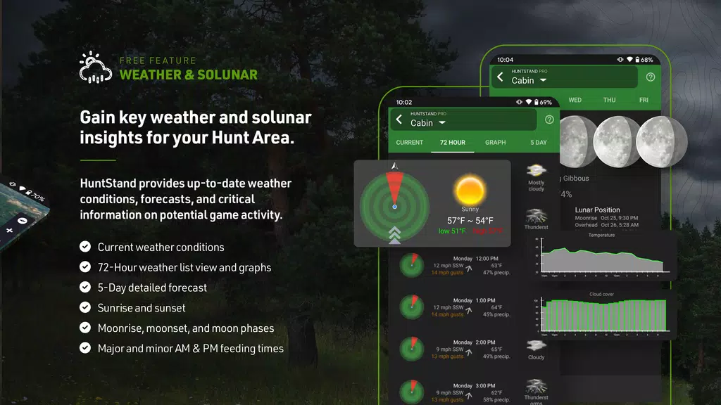
> Exclusive Whitetail Forecasts: With the 15-Day Whitetail Activity Forecast specific to your location, hunters can know the best times to hunt and increase their chances of success.
> Group Hunt Areas: The ability to share hunt areas with friends, lease partners, and family members seamlessly makes HuntStand a great tool for collaborative hunting efforts.
> Nationwide Property Lines: Access private and public property boundaries and curated public land maps nationwide for all 50 states and most of Canada. This feature helps hunters stay within legal boundaries and avoid trespassing.
FAQs:
> Is HuntStand available for free?
Yes, HuntStand is available for free to download and start mapping your hunting areas.
> Can I customize my hunt areas on HuntStand?
Yes, you can design detailed maps of your hunting areas, tailored to your specific needs, and share them with others.
> How accurate are the Whitetail Activity Forecasts on HuntStand?
The Whitetail Activity Forecasts are location-specific and provide accurate information about the best times to hunt in your area.
Conclusion:
With its comprehensive mapping tools, exclusive whitetail forecasts, group hunt area sharing feature, and nationwide property lines access, HuntStand: GPS Maps & Tools is the ultimate hunting and land management app for hunters across North America. Download HuntStand now for free and experience the value and power of this app in enhancing your hunting experience. Happy hunting!
Information
 Google Play
Old Versions
User Comments

With this innovative app, you can take control of all your location and tracking needs in one convenient place. From setting alarms and electronic fences to viewing live video and intercom feeds, gps51 does it all with ease. Stay connected and secure with the ability to manage multiple locators and IOT devices effortlessly. Whether you're monitoring your loved ones or keeping an eye on your belongings, gps51 provides the peace of mind you need. Say goodbye to the hassle of juggling multiple apps and devices, and hello to a seamless and user-friendly solution with gps51.

Experience luxury travel at your fingertips with Blacklane - Chauffeur Service. With service available in over 50 countries, you can book chauffeured rides for airport transfers, City to City journeys, or by the hour effortlessly. Choose from a variety of vehicle classes, including electric options, all 100% carbon offset. Enjoy peace of mind with 24/7 Customer Care, flight tracking, and flexible cancellation policies. Book your ride in just a few taps, track your chauffeur's location in real-time, and relax on your journey knowing payment is handled seamlessly through the app. For top-notch service and award-winning quality, Blacklane has you covered. Follow them on social media channels for travel inspiration and reach out for any support you may need.

Introducing UTM Measure, the ultimate tool for precise spatial measuring and analysis. UTM Measure allows users to accurately measure areas and distances, register points, lines and polygons from Satellite Imagery map data or GPS data. With advanced spatial drawing and editing tools, users can easily perform overlays, buffering and more. UTM Measure even supports various Coordinate Reference Systems from around the world, ensuring accurate plotting on maps. Plus, users can store unlimited data in their local database, export files in multiple formats, and access premium features like contour line creation. Experience the power of UTM Measure today and revolutionize your spatial analysis capabilities! Any feedback or suggestions can be sent to us via email or through a review on our site. Thank you for choosing UTM Measure!
Back Seat Navigator is not your average navigation app. If you're tired of boring, monotone voice prompts, this app is for you. Back Seat Navigator utilizes Mapbox technology to provide accurate turn-by-turn directions, but with a twist. Choose your level of profanity and insult settings to experience a navigation experience like no other. With selectable navigation modes, avoiding tolls, night and day modes, and an array of obnoxious directions, insults, and rerouting instructions, Back Seat Navigator will keep you entertained on every journey. Just remember to grant the necessary location permissions and consider subscribing for an ad-free experience. Drive with a side of sarcasm with Back Seat Navigator.

Discover the ultimate tool for navigating the bus and tram services in A Coruna with this innovative app. Tranvias Coruña provides easy access to real-time information on schedules, routes, and even allows you to save your favorite stops and lines for quick reference. With the option to view routes on Google Maps and receive important notices from the Tramways Company, Tranvias Coruña is a must-have for anyone looking to streamline their public transportation experience. Say goodbye to confusion and hello to convenience with iTranvias GUI.

With XPS Navigation, you can easily navigate to your tasks from the FleetXPS app using the advanced CoPilot navigation engine. Whether you're a professional driver or simply need help getting to your destination, this app is designed to meet the needs of all vehicle types and ensure a safe journey every time. Say goodbye to getting lost or taking wrong turns, and let XPS Navigation guide you seamlessly to your desired location. Download XPS Navigation today and experience hassle-free navigation like never before.