
 X
X
 facebook
 WhatsApp
 Email
Email
Introduction
Introducing UTM Measure, the ultimate tool for precise spatial measuring and analysis. UTM Measure allows users to accurately measure areas and distances, register points, lines and polygons from Satellite Imagery map data or GPS data. With advanced spatial drawing and editing tools, users can easily perform overlays, buffering and more. UTM Measure even supports various Coordinate Reference Systems from around the world, ensuring accurate plotting on maps. Plus, users can store unlimited data in their local database, export files in multiple formats, and access premium features like contour line creation. Experience the power of UTM Measure today and revolutionize your spatial analysis capabilities! Any feedback or suggestions can be sent to us via email or through a review on our site. Thank you for choosing UTM Measure!
Features of UTM Measure:
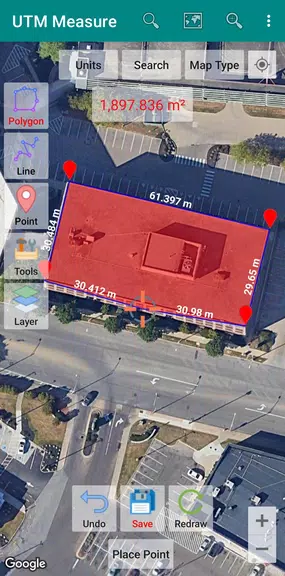
⭐ **UTM Measure:** The app allows you to measure area and distance, register points, lines, and polygons from Satellite Imagery map data or GPS data.
⭐ **Spatial Drawing & Editing Tools:** Equipped with sophisticated tools such as snap nearest, cutting/dividing polygons with lines, editing vertices of lines/polygons, and more for precise editing.
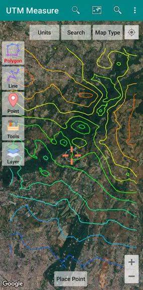
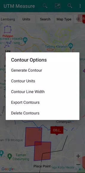
⭐ **Contour Line Creation (premium):** You can easily create contour lines to enhance the visualization of your data.
⭐ **Data Storage & Export:** Store an unlimited amount of data in your local database, including feature name information, photos, labels/notes, etc. Export your data to KML, DXF, or CSV files.
Playing Tips:
⭐ **Utilize Editing Tools:** Take advantage of the spatial drawing and editing tools to create accurate and detailed features on the map.
⭐ **Explore Contour Line Creation:** Experiment with creating contour lines to add depth and detail to your maps.
⭐ **Data Management:** Organize and store your data efficiently within the app's local database for easy access and management.
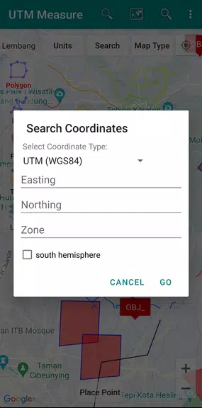
⭐ **Coordinate Systems:** Familiarize yourself with different Coordinate Reference Systems and use them to plot your polygons accurately on the map.
Conclusion:
With its advanced features for measurement, editing, data storage, and export capabilities, **UTM Measure** is a comprehensive tool for spatial analysis and mapping. Whether you are a professional in the field of GIS or a novice user looking to explore geographic data, this app provides the tools and functionalities to enhance your mapping experience. Download **UTM Measure** now and take your spatial analysis to the next level.
Information
 Google Play
User Comments

RidePueblo puts real-time transit information in your pocket so residents and visitors can navigate public transportation across the City of Pueblo with confidence. The app displays live arrival times and moving vehicle locations on an interactive map, shows route maps and timetables, and locates nearby stops based on your current GPS position. Whether you commute, attend classes, or are visiting for an event, RidePueblo helps reduce uncertainty by delivering current transit details in a compact, phone-friendly interface.

77 Transporte - Motorista is a dedicated driver app built to help professional drivers receive, evaluate and manage ride requests with speed and clarity. 77 Transporte - Motorista places emphasis on essential tools — timely trip alerts, a visible distance preview to help you decide whether to accept, and a direct call option that uses your device carrier for voice communication — so drivers can remain productive during active hours without unnecessary features getting in the way.

IZI Recarga EV is a practical mobile app designed to help electric vehicle drivers locate charging points, start and monitor charging sessions, and track consumption so everyday charging is simpler and more sustainable. The app puts a searchable map and session controls in your hands, offers clear billing and usage history to help plan trips and manage running costs, and connects drivers to a network of stations that prioritize renewable energy and predictable service.

Surf Life Log is a compact surfing logbook app that helps surfers record sessions, track conditions and choose better spots. The app lets you save date and time, location, wave size, wind direction and force, crowd level, photos, notes and personal ratings so you can review past rides and identify what works. Built for individual device use, Surf Life Log visualizes your activity with simple statistics and charts and includes a map-based surf-spot search. Surfers who want organized logs and clear insights into their preferred conditions will find this tool practical and straightforward.

ES Car - Motorista is a driver-focused mobile app built to connect professional drivers with nearby ride requests, enabling them to accept trips, manage pickups and improve daily earnings with clear, practical tools. The interface prioritizes real-time notifications so drivers see incoming offers immediately, and ES Car - Motorista gives a quick distance preview before a driver commits to a booking. With pre-registered users and an option to call passengers directly through the app for urgent coordination, the design emphasizes predictable interactions and safer exchanges between drivers and riders.

AUVES is a private transportation app designed to make requesting rides quick and predictable from your Android device; AUVES appears in this description to help you identify the service and understand how it fits into daily travel. From the initial booking screen you can set a pickup location, enter or select a destination, and review an estimated fare before confirming a trip. The app is built around straightforward controls and clear trip information so that both occasional users and regular commuters can complete bookings in seconds and monitor the ride in real time.