 X
X
 facebook
 WhatsApp
 Email
Email
Introduction
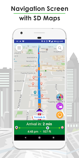
Live Roads - GPS Navigation, Offline Maps, 3D Cars sets itself apart from other navigation apps by offering a revolutionary experience with its Full Detail 3D Cars, HD Maps, and Lane-Level Navigation. With breakthrough features like HD Maps for detailed visuals and Real 3D Cars for a realistic driving experience, Live Roads takes car navigation into the 21st Century. Users can enjoy real-time traffic reports, incident reporting, and Picture-In-Picture maps for a higher level of accuracy and detail.
Features of Live Roads - GPS Navigation, Offline Maps, 3D Cars:
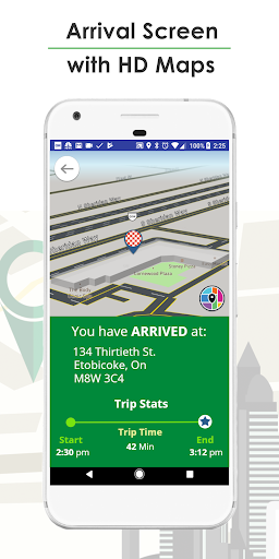
Revolutionary Lane Level Guidance & Navigation
Say goodbye to missed turns with Live Roads' Lane Level Guidance system. With road level detail and real-time lane accuracy, you can navigate with confidence. The intuitive guidance system provides the right information at the right time, ensuring a seamless driving experience.
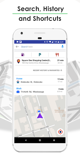
Live Traffic Reports
Stay informed with Live Roads' FREE and unlimited Real Time traffic reports. Easily avoid traffic congestion with detailed bidirectional road traffic reports. With Live Roads, you can always find the fastest route to your destination.
Real Time Incident Reporting & Viewing
Become a part of the Live Roads community by reporting incidents such as accidents, road construction, or police presence. By helping others avoid problem areas, you contribute to a safer and more efficient driving environment. Easily view incident details on your route to plan ahead and avoid delays.
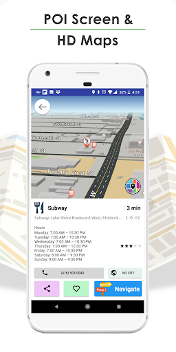
PIP Maps (Picture-In-Picture)
Experience a higher level of detail and accuracy with Live Roads' Picture-In-Picture (PIP) Maps feature. Toggle between HD and SD Maps effortlessly with just one button. Navigate with a birds-eye view while simultaneously viewing lane-level details, revolutionizing your driving experience.
Collect Drive Points & get Rewards
Earn Drive Points by driving with the Live Roads app open, reporting road incidents, and sharing the app with friends and family. Collecting >000 Drive Points will earn you a FREE month of Premium HD service, as a thank you for being an active member of the Live Roads Community. Drive Points can be accumulated quickly and easily, allowing you to access exclusive features and rewards.
Conclusion:
Live Roads - GPS Navigation, Offline Maps, 3D Cars is a revolutionary navigation app that takes car navigation to the next level with its HD Maps, Real 3D Cars, and Lane Level Guidance. With features such as Live Traffic Reports, Real Time Incident Reporting, PIP Maps, and Drive Points Rewards, Live Roads provides users with a unique and immersive driving experience. Try Live Roads today and discover a new way to navigate the roads with ease and precision. Download it now and start exploring the world around you like never before.
Information
User Comments

With this innovative app, you can take control of all your location and tracking needs in one convenient place. From setting alarms and electronic fences to viewing live video and intercom feeds, gps51 does it all with ease. Stay connected and secure with the ability to manage multiple locators and IOT devices effortlessly. Whether you're monitoring your loved ones or keeping an eye on your belongings, gps51 provides the peace of mind you need. Say goodbye to the hassle of juggling multiple apps and devices, and hello to a seamless and user-friendly solution with gps51.

Experience luxury travel at your fingertips with Blacklane - Chauffeur Service. With service available in over 50 countries, you can book chauffeured rides for airport transfers, City to City journeys, or by the hour effortlessly. Choose from a variety of vehicle classes, including electric options, all 100% carbon offset. Enjoy peace of mind with 24/7 Customer Care, flight tracking, and flexible cancellation policies. Book your ride in just a few taps, track your chauffeur's location in real-time, and relax on your journey knowing payment is handled seamlessly through the app. For top-notch service and award-winning quality, Blacklane has you covered. Follow them on social media channels for travel inspiration and reach out for any support you may need.

Introducing UTM Measure, the ultimate tool for precise spatial measuring and analysis. UTM Measure allows users to accurately measure areas and distances, register points, lines and polygons from Satellite Imagery map data or GPS data. With advanced spatial drawing and editing tools, users can easily perform overlays, buffering and more. UTM Measure even supports various Coordinate Reference Systems from around the world, ensuring accurate plotting on maps. Plus, users can store unlimited data in their local database, export files in multiple formats, and access premium features like contour line creation. Experience the power of UTM Measure today and revolutionize your spatial analysis capabilities! Any feedback or suggestions can be sent to us via email or through a review on our site. Thank you for choosing UTM Measure!
Back Seat Navigator is not your average navigation app. If you're tired of boring, monotone voice prompts, this app is for you. Back Seat Navigator utilizes Mapbox technology to provide accurate turn-by-turn directions, but with a twist. Choose your level of profanity and insult settings to experience a navigation experience like no other. With selectable navigation modes, avoiding tolls, night and day modes, and an array of obnoxious directions, insults, and rerouting instructions, Back Seat Navigator will keep you entertained on every journey. Just remember to grant the necessary location permissions and consider subscribing for an ad-free experience. Drive with a side of sarcasm with Back Seat Navigator.
Discover the ultimate tool for navigating the bus and tram services in A Coruna with this innovative app. Tranvias Coruña provides easy access to real-time information on schedules, routes, and even allows you to save your favorite stops and lines for quick reference. With the option to view routes on Google Maps and receive important notices from the Tramways Company, Tranvias Coruña is a must-have for anyone looking to streamline their public transportation experience. Say goodbye to confusion and hello to convenience with iTranvias GUI.

With XPS Navigation, you can easily navigate to your tasks from the FleetXPS app using the advanced CoPilot navigation engine. Whether you're a professional driver or simply need help getting to your destination, this app is designed to meet the needs of all vehicle types and ensure a safe journey every time. Say goodbye to getting lost or taking wrong turns, and let XPS Navigation guide you seamlessly to your desired location. Download XPS Navigation today and experience hassle-free navigation like never before.